| Copyright © Klaus Piontzik | ||
| German Version |
| The “World Magnetic
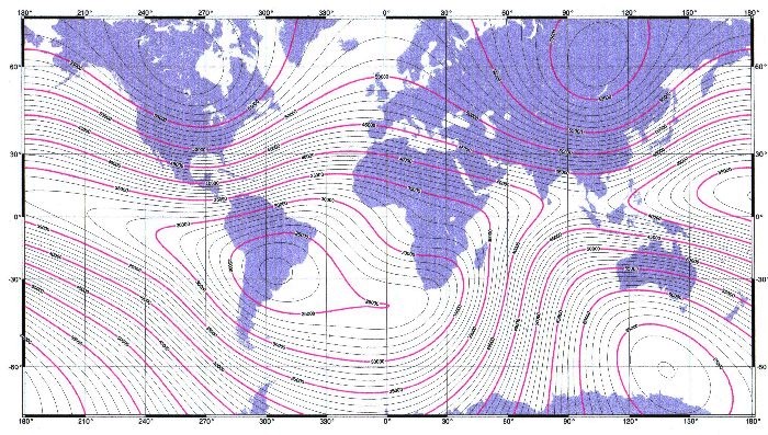
Model” (WMM) is a product of the U.S. National Geospa-tial-Intelligence Agency (NGA). You can relate the WMM 2005 about the "National Geophysical Data Center" (NGDC) now also via the Internet. The NGDC and the British Geological Survey (BGS) made the WMM with the support of the NGA in the United States, together with the "Defence Geograph-ic Imagery" and the "Intelligence Agency" (DGIA) from Great Britain. The WMM is used as a standard model for the US Department of Defense, the UK Ministry of Defence, the North Atlantic Treaty Organization (NATO), and the World Hydrographic Office (WHO). It is widely used in the civilian navigation. The model, the accompanying software and documentation are managed by the NGDC and the NGA. The model is made for every 5 years. The card of the total intensity is important to this investigation, as a particular type of evaluation is possible. So the total field total intensity at the earth's surface for the World Magnetic Model 2005 can be seen in the following illustration 4.3.1. |

| Illustration 4.3.1 – WMM 2005 |
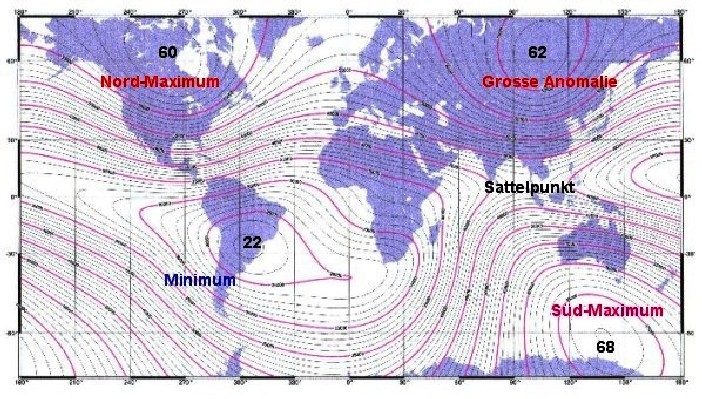
| What is striking here are the four extreme values ??of the field (and not just two as in the bar magnet or dipole model), with three maxima and one minimum. There is also a saddle point (e.g. in the Indonesia region) |

| Illustration 4.3.2 – extreme values of the field |
The names of the extreme values of the magnetic field is so commonplace in geophysics. |

|
200 sides, 23 of them in color 154 pictures 38 tables Production und Publishing: ISBN 978-3-7357-3854-7 Price: 25 Euro |